| Hana Kubickova

During last year's INSPIRE Hackathon the SmartAfriHubs Digital Innovation Hub (https://www.smartafrihub.com/cs/home) was developed. Moreover, there was a community built around it, which is now active on WhatsUp and Facebook. We would like this Hackathon to test possibilities of an extended environment, which will be more user friendly and which will allow large active sharing of information by users. It will not be focused only on publishing new maps, but also on developing content in the form of storyboards, producing active content from Africa, using of this content for better training and education, but also supporting sustainable development in Africa. We plan to extend the current community and increase visibility of this solution. There will be all data, which are currently stored on SmartAfriHubs available at the disposal of the hackers, moreover tools for easy data publishing and management, but also tools to develop storyboards and present actively different content connected with map information.
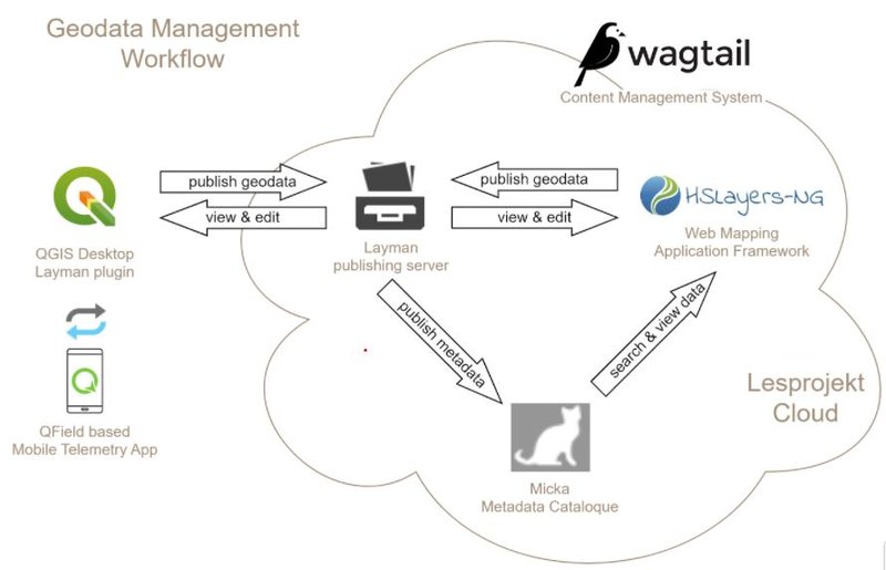
New solution, which is now under development, will be tested with different users. Current platform has architecture according new scheme:

This solution will be available on the Plan4all cloud and will be fully operational.
The basic unifying element of the geodata processing system will be the editorial system. It will enable the creation of a web portal and also provides a natural signpost to other parts of the system. The content management system will be based on the CodeRed CMS - https://www.coderedcorp.com/cms/ (Content Management System). This is one of the leading open source CMS used by small and large organizations (e.g. Google, NASA, British NHS). Wagtail is based on Django and the main development language is Python. It allows easy extension of functionality in the form of widgets, page templates, as well as permissions or other system parameters. It is therefore possible to integrate with other systems used within the organization (city geoportal, etc.) if such a requirement arises in the future. It is now connected with tools, which are already part of SmartAfriHub. The goal is to help different groups of people to build their own content (maps, text, storyboard and others and share it with the community. https://www.coderedcorp.com/cms/
We would like to discuss additional extensions of the system about new functionalities.
Introduction/Context
The Hackathon will have few steps, which we would like to realize:
- Training of participants, how to use single components and how to generate own context and also training about currently available data
- Definition of limited numbers of use cases and build a team, who will prepare full context and prepare attractive publication of this context
- Implementing of context
- Sharing of experiences from use cases and suggestion of improvements
- Preparing final presentation and plan for future sustainability
The ambition of the challenge
The main challenges are:
- to help African students and other people generate own content in attractive from
- to promote sustainability in African regions
- to generate new data
- to provide large scale awareness towards African communities
- to support future business
- to prepare scientific publications
Next steps
The main next step is to make new solutions self-sustainable and form a social space, including a broader community, which will help to introduce new technological concepts in Africa, support capacity building, and generate new data using principles of citizen science. Another important point is to define future development priorities.
MENTORS: Akaninyene Obot, Marketa Kollerova
